
Are More, Better? SAR Satellites and Challenges in the Philippines
Do you like tortoises? Do you like Blue Origin? Then maybe this article I wrote for Astralytical is for you. It contains a few of my reasons why BO is unlikely to get Blue Moon on the Moon next year: Blue Moon’s 2025 Moon Landing: Nope.
Satellite Businesses Don’t Exist in a Vacuum
I think I’ve been consistent and clear in analyses about satellites and their roles in humanity’s daily activities. The reason for deploying satellites is simple: their missions/services help people on Earth. The specifics of how satellites help depend on their services and the technologies they employ to deliver those services.
Positioning, navigation, and timing (PNT) services provide some of the space industry's most ubiquitous and impactful services, usually from the U.S. Global Positioning System (GPS) satellites. Weather and imagery satellites also provide beneficial information, although not quite to the level of PNT services.
Satellite services have proven extremely useful, especially to governments during and after disasters. One big reason for their use during disasters is that satellites usually suffer no impact from Earth's most significant natural disasters. From gulf-spanning hurricanes to volcanic eruptions, satellites orbit above everything, services intact. Communications, damage assessment, hotspots, etc., if there’s a way to receive a satellite’s service in the affected area, it can provide it immediately to aid in saving lives.
Disaster Preparedness and Response
Living on a series of islands complicates a government’s disaster response task. That’s why the Philippines is turning to Canada to gain access to data from space assets. The article focuses on Dark Vessel Detection, which has nothing to do with disaster response (but we’ll get to that later). For disaster response, the Philippine government faces several potential natural disasters, the most prominent of which appears to be volcanoes.
The Philippines has at least 24 active volcanoes, and its citizens must worry about volcanic eruptions, lava flows, and ashfall. The nation’s authorities in the MSN article mention that Canada’s Radarsat Constellation Mission (RCM) of three satellites with synthetic aperture radar (SAR) payloads will help with disaster response. Since we’re talking about government responses to disasters, and I don’t want people to confuse SAR with SAR (search and rescue), I’ll continue with the word “radar” for the payloads the satellites are hosting.
Earth observation (EO) satellites, especially those using radar, can help with disaster planning and response in several ways. For one thing, these satellites can be assigned (tasked) to look at all 24 volcanoes whenever they pass overhead. Their data would be added to the data from other tools used to monitor volcanoes.
Satellites with radar payloads could be used to look for minute changes that indicate ground displacement as magma builds up. The ability to see those small changes could provide more accurate and quicker evacuation warnings to citizens living close to a volcano that’s about to erupt. Another possible use for satellite radar is to determine the direction of the lava flow. Although, and this is a critical aspect of using satellite radar that way, researchers noted:
The ever-growing number of public and private satellite SAR missions will provide for improved temporal resolution in SAR VFMs in the future, and the technique may be suitable for automated analysis that is capable of timely identification of changes due to volcanic activity, even in areas that are otherwise unmonitored.
More Satellites, More Passes=More Data
The three RCM satellites are not enough to set up an automated analysis of SAR VFMs (volcanic flow maps)—not if the Philippine authorities are looking for data updated more frequently than once a day. And the same shortcoming can be attributed to the Canadian satellites detecting the ground displacement occurring around an active volcano that will erupt. Three satellites, while better than nothing, aren’t enough.
The solution to this volcano problem will also help others facing challenges with volcanoes, whether on islands or continents. The quote noted the “ever-growing” commercial companies operating satellites with radar payloads. Many commercial radar satellites have been deployed in the Earth’s orbit in recent years, outnumbering civil and military radar satellite deployments.
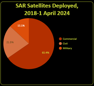
From 2018 through April 1, 2024, satellite operators deployed an estimated 107 satellites with radar payloads. Over 65% (~70) were for commercial missions and are operated by 13 companies. The top three companies operating the most radar satellites are Iceye, Capella Space, and Umbra Lab. Those three companies employ nearly 50 of the 70 commercial radar satellites in operation today.
The Philippine government could approach Umbra, the company operating the fewest radar satellites (This is no longer true. I was reminded that Capella deorbited quite a few satellites, with four remaining.) in that trio, and still access nearly triple the satellites (and collection opportunities) than by using RCM alone. But why not try to access them all somehow, not just Umbra’s or RCM? Wouldn’t the aggregated observations result in more than adequate coverage over time to accurately determine volcanic displacement and lava flows?
DVD–Using More Than SAR
Maybe that’s the plan, but the spare numbers of RCM satellites also apply to the other challenge the Philippines is attempting to surmount: illegal, unreported, and unregulated (IUU) fishing. The Philippine government has had challenges with IUU in its waters, losing over an estimated million metric tons of fish annually. A potential solution to the Philippines’ challenge is the Dark Vessel Detection (DVD) program offered by Canada.
A big caveat (for commercial companies) of the program is that it’s free to the Philippines. Another is that the DVD name is used by other space companies such as Iceye and MDA (coincidence?). All DVD programs advertise they can identify boats/ships that have deliberately turned off identification transponders (or don’t turn them on) for IUU, smuggling, and other illegal activities.
But while Canada’s RCM satellites can provide information to help the Philippine authorities identify dark vessels, are three enough to provide updated information quickly? After all, boats move.
As an aside, the Canadian DVD program uses data from other sources in addition to its RCM satellite data. It appears to rely on a combination of AIS (automatic identification system) ship tracking, radio frequency monitoring services such as those from HawkEye 360 or maybe the US government, and some optical space products.
It’s not just those products, however. It’s also how the Canadian government is fusing and analyzing that data for the use of nations such as the Philippines. Canada’s military, in particular, has likely had to rely on similar homegrown analysis cells for space products from partner nations. I don’t believe that there’s a commercial company that has an equivalent capability.
That latter fact might make it difficult for commercial radar satellite operators to directly offer their products to the Philippine government even though they have more satellites available. Maybe they could work with the Canadian government to integrate their products into its programs, hopefully making a profit that way. It may be that the Canadian government is waiting for a commercial Canadian equivalent of an Iceye or Capella so that it can subsidize, er, contract with a Canadian company.
It’s interesting to see the Canadian government offering space radar products to the Philippine government to help solve another challenge. More interesting is just how limited it is by the small number of radar satellites it uses to do so. That limitation should intrigue commercial radar satellite operators and encourage them to kick their operations into high gear.
Remember, commercial companies are operating an estimated TOTAL of 70 radar satellites deployed since 2018, which is many more radar satellites than have ever been deployed in the past. However, the total is still tiny compared to those that commercial optical satellite operators have deployed (over 550 during the same time).
The radar satellite companies may be more hesitant to deploy more spacecraft because they are observing their optical counterparts and the challenges they are encountering. However, deploying more radar satellites might prove more attractive to more customers with problems similar to those confronting the Philippines, despite them having to pay for it.
If you liked this article (or any others from Ill-Defined Space), any donations are appreciated. For the subscribers who have donated—THANK YOU!!


Comments ()