
State Wildfires and DoD Infrared Satellites

It’s no secret that infrared satellites are of particular interest to me. I’ve written a few analyses of the Department of Defense’s various missile warning satellites and that department’s inept culture of program management as it procures new versions. Which is one of the reasons why this New York Times article “The Secret War Over Pentagon Aid in Fighting Wildfires” caught my eye. It’s a good read, and most of the facts appear accurate.
I understand the frustrations of the federal government appearing to have a resource that seems unresponsive to state issues. Wildfires, in particular, are seemingly annually occurring life- and property-threatening disasters that certain states, particularly those in the west, must deal with. So, to see several in-space assets that appear to be only a phone call away, but find that they can’t be tasked to that state’s needs, must be perplexing and angering.
And that’s what appears to be the state of mind of California’s Governor Newsom as he appeals to President Biden for intervention in tasking military infrared satellites to focus on U.S. soil and property. After all, the U.S. military has demonstrated in the past how infrared data can augment optical satellite imagery to identify fire flare-ups in California. Using existing government military satellites seems sensible fiscally as well and drums up state support for military infrared systems. A space system that can be used for U.S. national defense and state needs? Sold! It should be noted that the addition of civil applications to the infrared satellite mission portfolio is not new...it's been promoted for a few decades now.
But...it’s not a good idea for several reasons.
The View from Above
For one thing, monitoring forest fires in the U.S. is literally not the focus of the satellites themselves. Take a look at the Satellite ToolKit (STK) model I ginned up below:
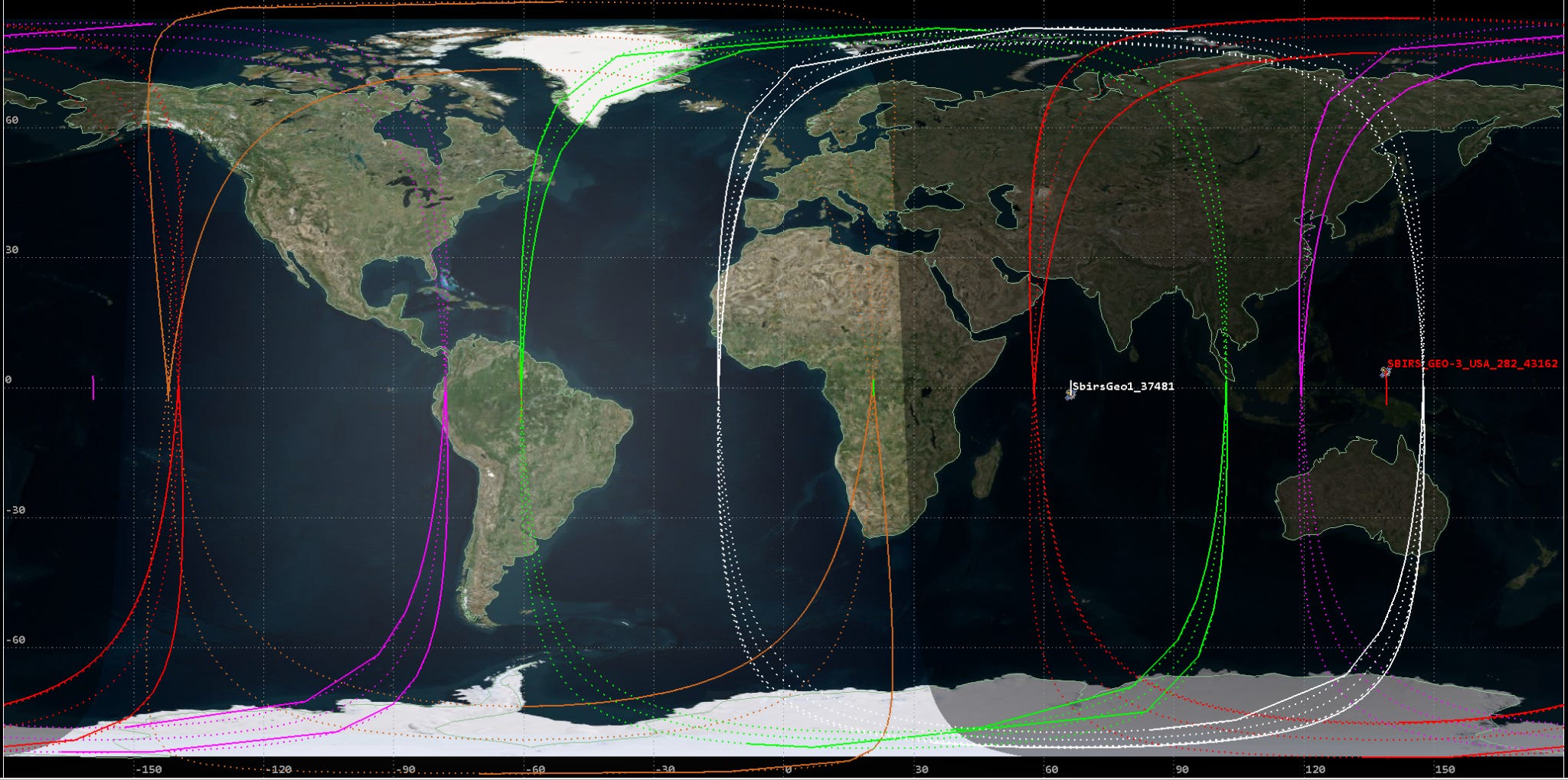
A caveat: I don’t know how accurate the STK model is, but I am assuming it’s accurate enough for this analysis.
The model displays the outlines of the fields of regard (FOR) from five different Space Based Infrared System (SBIRS) satellites in geosynchronous orbit. SBIRS satellites are supposed to have two sensors onboard, but that’s beside the point. Notice how many satellites appear to be covering Europe (Russia), the Middle East (take your pick), and Asia (China and North Korea). There are so many that they overlap in some areas. For example, one area has four GEO SBIRS satellites covering it, with adjoining areas in the FOR of three.
Compare that number to the SBIRS satellites covering the entire continental U.S. The result is a maximum of two satellites covering the U.S. at any given time, except for the eastern seaboard from about the South/North Carolina border on up, where only one SBIRS satellite provides coverage. That kind of makes sense, depending on a person’s view of the importance of Washington DC. This minimal coverage of the U.S. shows where the DoD believes infrared technology can best be used.
There are also the SBIRS payloads on some classified satellites in highly elliptical orbits, which aren’t included in the model. But, you can bet that those sensors are focused on areas of significant interest (not usually wildfires), too. Note that this model doesn’t include the older Defense Support Program (DSP) satellites, which provide additional infrared data to the SBIRS constellation.
This focus on areas other than the U.S., though, shouldn’t come as too big a shock when a person thinks about the news coverage of certain nations behaving anti-socially. The U.S. has an interest in gaining some kind of awareness of their activities. It also should become much more apparent when one understands that the primary purpose of this constellation is to detect missile launches early enough to give decision-makers as much of a warning as possible. Anything else, such as technical intelligence, missile defense, battlespace awareness, and civil applications, are icing on the cake.
Mission Focus and Prioritization
That last mission category--civil applications--is where monitoring and reporting wildfires to state governments would likely fall--if it were ever implemented. These mission categories define the mission focus of the SBIRS operators, guiding their decisions as they try to fulfill mission tasks. To be clear, the folks operating the consoles and conducting the analyses of whatever events their satellites detect are professionals. They will accomplish all legal and valid orders given, using the tools at hand to do so. But they will focus on their priority mission--missile warning--then maybe technical intelligence, missile defense, battlespace awareness, and civil applications (in that order).
These SBIRS operators will face boring shifts, but here’s a statistic to show how busy they can potentially be in a year: 1,000+ launches. That is how many launches these operators processed during 2020. That comes to nearly three launches a day, with most of those likely unannounced (why would China or Russia announce missile tests to the U.S. military?). Note that space launches take a tiny share of those launches with 111. Each of those events takes the crew’s focus, requiring time to understand the nature of those launches and whether they threaten the U.S.
Those are just launches, but this article highlights a few of the other infrared energy sources they are interested in: afterburning aircraft, artillery fire, missile batteries. Of course, that list is only of the infrared sources the DoD has chosen to divulge. Still, one can imagine a much longer list--all with a higher priority (rightfully so!) than monitoring wildfires over the U.S. Yes, the SBIRS operators can likely monitor more than one area at a time. But does the U.S. want its military to work part-time as space forest rangers or focus on their duty as military space force operators?
The idea of using military assets and personnel to accomplish what is, in essence, a civil duty is a misuse of both. So, sure, even a single SBIRS satellite can detect wildfire flare-ups in the U.S., and operators, if they have time, might be able to notify someone about a possible wildfire when detected. Frankly, however, the mission is to warn the U.S. of missile launches, a vital mission requiring timely decisions and communications. So, no matter how bored the operators are, their focus should be on what’s possibly rising from those areas of interest, not on fires from California’s or Colorado’s forests.
Additionally, those infrared sensors aren’t optimized for wildfire detection, and while they can be used to detect wildfires, that doesn’t mean they are the best tool for the job. Heck, the satellites used to monitor the U.S. might be old (because the DoD wants its newest and best SBIRS satellites over the areas of interest). Based on the New York Times article, it’s also apparent that the communication network for notifying the right people in the right state of a fire’s existence doesn’t even exist.
The Opportunity
Instead of forcing a square peg into a round hole with SBIRS and the DoD, California’s and other states’ wildfire dilemmas seem to present an opportunity to go a different way.
According to the article, Newsom is making an appeal to the U.S. military and the President to get the military to share data that may or may not be helpful. Why not contract with a commercial satellite manufacturer and operator to build a LEO (or maybe GEO--it depends) constellation with IR sensors onboard to monitor for wildfires? Identify what the state and all stakeholders in wildfire management truly need and tailor the constellation to fulfill them. It would cost less than a single year’s worth of property losses in California ($13-12 billion, depending on the year)--or maybe even a single SBIRS satellite. It will undoubtedly cost less than the Next Generation Overhead Persistent Infrared constellation the military wants to implement ($14.4 billion at least).
It doesn’t have to be complex (no crosslinks, etc.), and the operator would be given the option to contract with other states, such as Colorado, Arizona, etc., for the same service. Thus, there would be no tasking conflicts stemming from Chinese or Russian activities. Even better, there would be no worries about divulging classified information, as the service is a commercial offering, which means less friction for passing data from the sensor to the first responders. The commercial service will be focused on only one thing--detecting and reporting wildfires so that firefighters can get to an area before a fire gets out of hand.
However, the one caution is NOT to ask the defense companies for this constellation. That’s the way to the poorhouse, full of schedule delays and unneeded complexity. Instead, look at the new options and services available in space. For that matter, maybe look to see if there’s something available on Earth that is less expensive but at least as effective as satellite sensors.
California is a prosperous state, full of technology powerhouses and startups, including some working in the space sector. A few portray themselves as innovative companies, and some of those might well be. It could be the state has an answer for wildfire monitoring in its backyard, one which would result in more employment, revenue generation, and tax-paying while answering a genuine need.
That’s better than begging for a point of contact for SBIRS any day...and then waiting for a response.


Comments ()